Everest 1951: Eric Shipton, Edmund Hillary, and the Secret Door of Khumbu
In the autumn of 1951, legendary explorer Eric Shipton led a British party into the newly opened valleys of Nepal, unlocking the monstrous Khumbu Icefall and discovering the path that conquered Everest.
Mountain Safety & Conditions Disclaimer: High-altitude climbing, glacial travel, and technical ascents entail severe objective risks including avalanches, serac collapses, rapid weather collapse, and altitude illness. Historical route descriptions and summit claims on Mountanity reflect documented archival sources and must not be used as live operational safety assessments. Local regulations, permits, and physical glacial topography change continuously.
Peer Review: Senior Editorial Board & Historical Reviewers • Editorial Standards
For thirty years, between 1921 and 1938, the battle for Mount Everest had been fought exclusively on the frozen northern limestone plains of Tibet. Expeditions organized by the British Mount Everest Committee had marched hundreds of miles across the high plateau to approach the mountain via the Rongbuk Glacier and the North Col. But in 1950, a sudden tectonic geopolitical shift slammed the northern door shut: Chinese communist troops entered Tibet, strictly sealing its borders to Western explorers.
Simultaneously, an unexpected southern door opened. For centuries, the isolated mountain kingdom of Nepal had preserved its hermit status, forbidding foreign travelers from setting foot in the sacred valleys of the Sherpas. Following the end of the Rana dynasty in early 1951, King Tribhuvan granted permission for a small British team to explore the southern approaches to Everest through the Solukhumbu region.
To lead this critical reconnaissance, the Joint Himalayan Committee turned to the greatest living master of exploratory mountaineering: 44-year-old Eric Earle Shipton.
The Team and the New Zealand Invaders
Shipton immediately assembled a lean, agile team reflecting his minimalist philosophy: Dr. Michael Ward, an army medical officer and alpinist; Tom Bourdillon, a brilliant Oxford physicist and oxygen equipment specialist; and William Murray, a Scottish climber and philosopher.
While finalizing plans in London, Shipton received an urgent telegram from the New Zealand Alpine Club informing him that a four-man New Zealand expedition was already climbing in the Garhwal Himalayas. Intrigued by their reputed physical toughness, Shipton generously invited two of them to join the Everest reconnaissance: Earle Riddiford and a towering, 32-year-old commercial beekeeper from Auckland named Edmund Hillary.
When Hillary and Riddiford joined Shipton in late August 1951, Hillary was immediately captivated by Shipton’s unassuming leadership, dry wit, and total lack of bureaucratic pomp. As Hillary later recalled: “Shipton was the hero of our youth… He moved through the mountains with an easy grace and a quiet modesty that made you want to follow him anywhere.”
The Revelation from Pumori
Departing Kathmandu in late August, the expedition trekked through monsoon downpours across the terraced green foothills of Nepal, entering the high granite valleys of the Khumbu. Establishing Base Camp on the moraine gravel of the Khumbu Glacier in late September, they found themselves in a dramatic, towering amphitheater of ice.
To understand the mountain’s topography, Shipton, Hillary, and Bourdillon scrambled up the steep south ridge of neighboring Pumori to an altitude of approximately 6,100 meters (20,000 feet). Looking southeast through their binoculars, they were granted an astonishing, unobstructed view into the heart of Everest.
Before them lay the great, hidden glacial valley of the Western Cwm—a vast, sun-drenched basin suspended between the colossal vertical precipices of Everest, Lhotse, and Nuptse. At the head of the Cwm, rising above the upper glacier, was the shining 45-degree blue-ice wall of the Lhotse Face, leading directly onto the broad, snow-mantled saddle of the South Col at 7,925 meters. From the South Col, a continuous snow and rock ridge climbed steeply up to the South Summit and the ultimate crest of Everest.
Shipton lowered his binoculars and smiled: the southern highway to the highest point on Earth existed.
The Monster in the Throat: The Khumbu Icefall
However, between their vantage point and the entrance to the Western Cwm lay a terrifying obstacle: the Khumbu Icefall. Here, the immense glacier plunging out of the Western Cwm dropped two thousand vertical feet over a sheer granite lip, shattering into a chaotic, nightmarish labyrinth of towering blue-ice seracs, collapsing ice towers the size of cathedrals, and gaping, bottomless crevasses.
Older Himalayan hands had warned that the icefall was impassable and suicidal. In late October, Hillary, Shipton, Bourdillon, and Riddiford strapped on crampons and entered the frozen labyrinth.
Moving through stifling daytime heat that reflected off the white walls like an oven, the climbers methodically hacked steps in vertical ice walls, bridged narrow snow bridges, and ducked beneath overhanging seracs that groaned and creaked ominously in the sun. Hillary, with his immense physical reach and boundless energy, took the lead on the sharp end of the rope, leaping across yawning chasms and anchoring ropes for his companions.
Near the very top of the icefall, at an altitude of approximately 6,100 meters, they stood on the brink of the Western Cwm. Only one final obstacle blocked their entrance: an enormous, monstrous crevasse, nearly 100 feet wide and hundreds of feet deep, spanning the entire breadth of the glacier. Lacking aluminum ladder sections, Shipton prudently called a halt. The route had been surveyed and its feasibility confirmed; siege equipment would be brought by the full assault expedition.
The Footprint of the Yeti
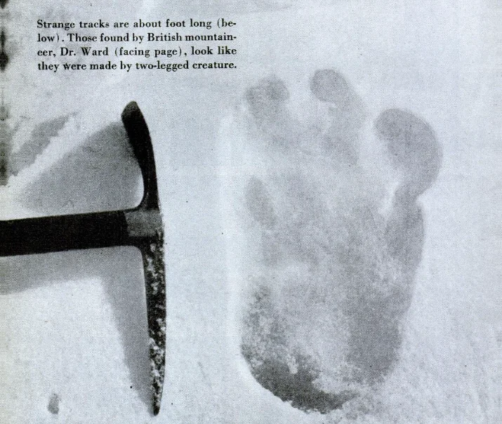
During a side reconnaissance into the unmapped Menlung Basin west of Everest in November, Shipton and Dr. Michael Ward made an astonishing discovery. Crossing a snow col at 5,800 meters, they stumbled upon a fresh, clearly defined track of footprints stretching across the untracked glacier.
Unlike bear tracks or snow-leopard prints, the footprints were distinctly bipedal, measuring thirteen inches in length and eight inches across, showing a large, broad toe and four smaller digits. Shipton took out his ice axe, laid it alongside one of the immaculate prints for scale, and exposed several large-format photographs.
When published in the British press, Shipton’s photograph of the “Yeti footprint” caused an international sensation, captivating scientists, zoologists, and adventurers worldwide and cementing the mythical Abominable Snowman into global folklore.
The Foundation for 1953
By late November 1951, the expedition returned to Kathmandu. Eric Shipton submitted a comprehensive, triumphant report to the Royal Geographical Society: the southern approach through Nepal was entirely viable, the Khumbu Icefall could be negotiated with fixed ladders, and the Western Cwm offered a sheltered sanctuary leading to the South Col.
Shipton’s brilliant reconnaissance provided the precise tactical blueprint that allowed the Swiss to push to 8,600m in 1952, and enabled Sir John Hunt, Edmund Hillary, and Tenzing Norgay to achieve the immortal maiden first ascent of Mount Everest on May 29, 1953.
Key Statistics & Topographic Figures
- Category
- Historic Expeditions
Archival Subject
- Reading Time
- 13 min read
Narrative Length
- Key Mountain
- mount-everest
Objective
- Ascent Route
- south-col-route
Topography
- Verification
- Editorially Verified
Archival Standard
Archival Primary Source Quotations
“In the mountains, truth is etched in ice and granite; every step requires unwavering respect for the heights.”
Defined Alpine Terminology & Concepts
- Summit Push
- The final continuous climbing effort from the highest established camp to the mountain apex and back.
- Death Zone Chronicle
- A verified, research-backed historical narrative documenting the human, technical, and environmental realities of an alpine expedition.
Frequently Asked Questions: Everest 1951: Eric Shipton, Edmund Hillary, and the Secret Door of Khumbu
What is the core chronicle and subject of "Everest 1951: Eric Shipton, Edmund Hillary, and the Secret Door of Khumbu"?
In the autumn of 1951, legendary explorer Eric Shipton led a British party into the newly opened valleys of Nepal, unlocking the monstrous Khumbu Icefall and discovering the path that conquered Everest.
Which mountain peaks and routes are featured in "Everest 1951: Eric Shipton, Edmund Hillary, and the Secret Door of Khumbu"?
This narrative documents climbs on mount-everest along the south-col-route in Nepal.
Which documented expedition is chronicled in this story?
This historical chronicle captures the events of the 1951-british-everest-reconnaissance, verified through contemporary journals and archival records.
Who authored and researched this archival chronicle?
Authored and researched by Mountainity Historical Research Desk, drawing on primary eyewitness testimonies, alpine club registries, and verified summit logs.
What makes this high-altitude chronicle historically significant?
Categorized under "Historic Expeditions", this chronicle preserves critical lessons in alpine leadership, survival, tactical speed, and human endurance in the death zone.
Related Mountains


Mount Everest
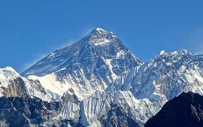
Mount Everest is the highest mountain above sea level on Earth, standing at an official elevation of 8,848.86 meters (29,031.7 ft). Straddling the international frontier between Nepal and China, it is known locally as Sagarmatha in Nepali ('Goddess of the Sky') and Chomolungma in Tibetan ('Mother Goddess of the World'). The peak rises into the extreme upper troposphere, where oxygen levels drop to barely one-third of sea-level pressure. Climbers face hurricane-force jet stream winds, severe frostbite conditions, shifting ice crevasses in the Khumbu Icefall, and the dangerous Death Zone above 8,000 meters.
Documented Sources & Archival Citations
- The Mount Everest Reconnaissance Expedition 1951(Eric Shipton / Hodder & Stoughton)
Supporting claim: Official expedition chronicle detailing the Khumbu Icefall breach and Western Cwm reconnaissance
Accessed/Documented: 1952 - High Adventure(Sir Edmund Hillary / Hodder & Stoughton)
Supporting claim: Hillary's personal eyewitness account of climbing with Shipton and exploring the lower icefall
Accessed/Documented: 1955 - The Alpine Journal Archive: The 1951 Reconnaissance of Everest(The Alpine Club UK)
Supporting claim: Cartographic evaluation and route confirmation leading to the 1953 expedition
Accessed/Documented: 1952