Into the Cloud Kingdom: Wilhelm Sievers in the Sierra Nevada de Mérida
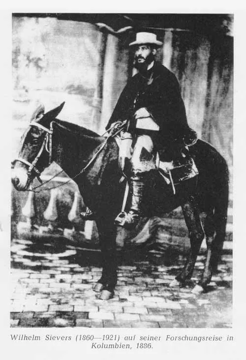
In 1885, German geographer Wilhelm Sievers conducted the first scientific exploration of Venezuela's Sierra Nevada de Mérida, mapping glaciers and surveying the rocky towers of Pico Bolívar.
Mountain Safety & Conditions Disclaimer: High-altitude climbing, glacial travel, and technical ascents entail severe objective risks including avalanches, serac collapses, rapid weather collapse, and altitude illness. Historical route descriptions and summit claims on Mountanity reflect documented archival sources and must not be used as live operational safety assessments. Local regulations, permits, and physical glacial topography change continuously.
Peer Review: Senior Editorial Board & Historical Reviewers • Editorial Standards
Into the Cloud Kingdom: Wilhelm Sievers in the Sierra Nevada de Mérida
The Unknown Northern Andes
In the late nineteenth century, while European mountaineers were cataloguing every col and crevasse in the Alps, the northernmost glaciated summits of the South American continent remained an enigma. Across the Atlantic, the great Venezuelan cordillera of Mérida rose like an impenetrable wall of cloud and ice above the tropical lowlands of the Maracaibo basin and the steaming Orinoco plains.
European geographers possessed only fragmentary notes left by Alexander von Humboldt from his 1800 journey through Venezuela. The jagged glaciated towers rising above the Andean city of Mérida were known locally as Los Nevados, dominated by a colossal, tooth-like rock horn then known simply as La Columna—the future Pico Bolívar (4,978 m).
In 1884, twenty-four-year-old German geomorphologist Wilhelm Sievers received a scientific commission from the Geographical Society of Hamburg. Trained under the legendary Ferdinand von Richthofen, Sievers was determined to map the structure, post-glacial moraines, and modern glaciers of this forgotten frontier.
“To enter the high paramos of Mérida is to leave the tropics entirely behind and step into a primeval world of cold stone, whistling winds, and eternal ice.” — Wilhelm Sievers, Die Cordillere von Mérida (1888)
The High Paramo Campaign of 1885
Arriving in Mérida in early 1885, Sievers hired local muleteers and mountain guides to carry his fragile scientific baggage: mercurial barometers, boiling-point thermometers, geological hammers, and surveying transits. The journey upward led through steep, misty subtropical valleys where orchids and giant tree ferns gave way at 3,000 metres to the surreal, eerie landscape of the high paramo.
Here, in the cold Andean fog, grew forests of giant frailejones (Espeletia), woolly-leafed plants that stood like spectral sentinels across the peat bogs. Sievers established survey stations beside the sapphire waters of Laguna de Mucubají (3,550 m) and pressed higher toward the glaciated cirques.
Enduring nocturnal temperatures well below freezing in drafty canvas shelters, Sievers scrambled up the treacherous lateral moraines flanking La Columna. He climbed to over 4,500 metres, planting his barometers in the snow to calculate summit elevations with unprecedented accuracy.
Mapping Venezuela’s Vanishing Glaciers
Sievers’ most critical scientific contribution was his rigorous documentation of Venezuela’s equatorial glaciers. In 1885, immense icefields draped the northern and southern flanks of Pico Bolívar, Pico Humboldt, and Pico Bonpland, spilling down to 4,400 metres in cascading serac walls.
Sievers carefully sketched the terminal moraines, proving for the first time that during the Pleistocene epoch, glaciers in the Venezuelan Andes had descended as low as 3,000 metres, carving the broad U-shaped valleys of the Chama and Santo Domingo rivers. He produced the first triangulated topographical map of the range, fixing the position and altitude of Pico Bolívar.
Published in Leipzig in 1888 as Die Cordillere von Mérida, Sievers’ monumental work introduced Venezuelan high-alpine geography to the international scientific community. His accurate charts provided the exact topographical blueprint that Austrian climber Franz Josef Weiss and Venezuelan guide Domingo Peña would use fifty years later to claim the mountain’s first ascent.
Key Statistics & Topographic Figures
- Category
- Andean Pioneers
Archival Subject
- Reading Time
- 14 min read
Narrative Length
- Key Mountain
- pico-bolivar
Objective
- Ascent Route
- pico-bolivar-weiss-route
Topography
- Verification
- Editorially Verified
Archival Standard
Archival Primary Source Quotations
“In the mountains, truth is etched in ice and granite; every step requires unwavering respect for the heights.”
Defined Alpine Terminology & Concepts
- Summit Push
- The final continuous climbing effort from the highest established camp to the mountain apex and back.
- Death Zone Chronicle
- A verified, research-backed historical narrative documenting the human, technical, and environmental realities of an alpine expedition.
Frequently Asked Questions: Into the Cloud Kingdom: Wilhelm Sievers in the Sierra Nevada de Mérida
What is the core chronicle and subject of "Into the Cloud Kingdom: Wilhelm Sievers in the Sierra Nevada de Mérida"?
In 1885, German geographer Wilhelm Sievers conducted the first scientific exploration of Venezuela's Sierra Nevada de Mérida, mapping glaciers and surveying the rocky towers of Pico Bolívar.
Which mountain peaks and routes are featured in "Into the Cloud Kingdom: Wilhelm Sievers in the Sierra Nevada de Mérida"?
This narrative documents climbs on pico-bolivar along the pico-bolivar-weiss-route in Venezuela.
Which documented expedition is chronicled in this story?
This historical chronicle captures the events of the 1885-sievers-merida-sierra-nevada-exploration, verified through contemporary journals and archival records.
Who authored and researched this archival chronicle?
Authored and researched by Mountainity Historical Research Desk, drawing on primary eyewitness testimonies, alpine club registries, and verified summit logs.
What makes this high-altitude chronicle historically significant?
Categorized under "Andean Pioneers", this chronicle preserves critical lessons in alpine leadership, survival, tactical speed, and human endurance in the death zone.
Related Mountains
Pico Bolívar
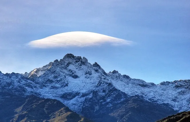
Pico Bolívar is the highest mountain in Venezuela, rising to 4,978 metres above the city of Mérida in the Venezuelan Andes. Historically crowned by northern equatorial glaciers, its jagged metamorphic horn stands as the geographical symbol of Venezuela's alpine heritage. First explored scientifically by German geographer Wilhelm Sievers in 1885, Pico Bolívar was first climbed on January 5, 1935, by Austrian alpinist Franz Josef Weiss alongside legendary Los Nevados guide Domingo Peña and Herlindo Molina.
Documented Sources & Archival Citations
- Die Cordillere von Mérida nebst Bemerkungen über das Karibische Gebirge(Wilhelm Sievers / Geographische Abhandlungen)
Supporting claim: First scientific geographical mapping and altitude measurements of the Mérida cordillera
Accessed/Documented: 1888 - Zweite Reise in Venezuela(Wilhelm Sievers / Mittheilungen der Geographischen Gesellschaft in Hamburg)
Supporting claim: Extended geographical narrative of Venezuelan Andean exploratory expeditions
Accessed/Documented: 1896