Ama Dablam
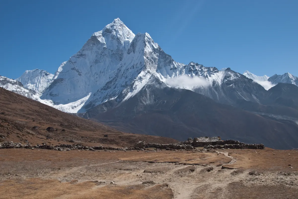
Ama Dablam is an iconic 6,812-meter (22,349 ft) mountain in the eastern Himalayan region of Nepal. Renowned worldwide for its soaring granite ridges and hanging glaciers, it is often called the Matterhorn of the Himalayas.

Mountain Safety & Conditions Disclaimer: High-altitude climbing, glacial travel, and technical ascents entail severe objective risks including avalanches, serac collapses, rapid weather collapse, and altitude illness. Historical route descriptions and summit claims on Mountanity reflect documented archival sources and must not be used as live operational safety assessments. Local regulations, permits, and physical glacial topography change continuously.
Peer Review: Senior Editorial Board & Historical Reviewers • Editorial Standards
Geographical Setting & Topography
Sagarmatha National Park, Khumbu region, Solukhumbu District, Nepal.
Historic First Ascent
Date: January 15, 1961
Ascent Team: Mike Gill, Barry Bishop, Michael Ward, and Wally Romanes (Sir Edmund Hillary's Silver Hut Expedition)
Key Statistics & Topographic Figures
- Official Elevation
- 6,812 Meters
22,349 ft (Khumbu Region)
- Topographic Prominence
- 1,041 Meters
Independent Himalayan spire
- First Ascent Date
- January 15, 1961
Hillary Silver Hut Expedition
- Normal Route
- Southwest Ridge
French TD, UIAA V+, WI4
- Yellow Tower Crux
- 5,800 Meters
15m vertical granite headwall (5.7)
- Camp II Bivouac
- 5,900 Meters
Exposed granite pinnacle aerie
Archival Primary Source Quotations
“Ama Dablam is an unforgettable pyramid of granite and ice, a mountain that commands awe from every vantage point in the Solukhumbu.”
Defined Alpine Terminology & Concepts
- The Dablam
- A prominent hanging glacier resembling a sacred pendant or necklace box (dablam) worn by Sherpa women, crowning the upper face of Ama Dablam.
- Yellow Tower
- A famous 15-meter vertical golden granite pitch at 5,800 meters on the Southwest Ridge of Ama Dablam, rated UIAA V+ / 5.7 rock.
Ama Dablam Mountain Weather Forecast
Detailed 14-Day Summit Window & Weather Timeline
Explore day-by-day summit push safety windows, wind shear analysis, and extended multi-day forecasts for Ama Dablam.
Explore Ama Dablam (6,812 m) in Interactive 3D
Inspect steep glacial walls, hanging seracs, ridge approaches, and elevation relief with 360° rotation and terrain tilt in WebGL.
Documented Climbing Routes (1)
Southwest Ridge of Ama Dablam (Normal Route)
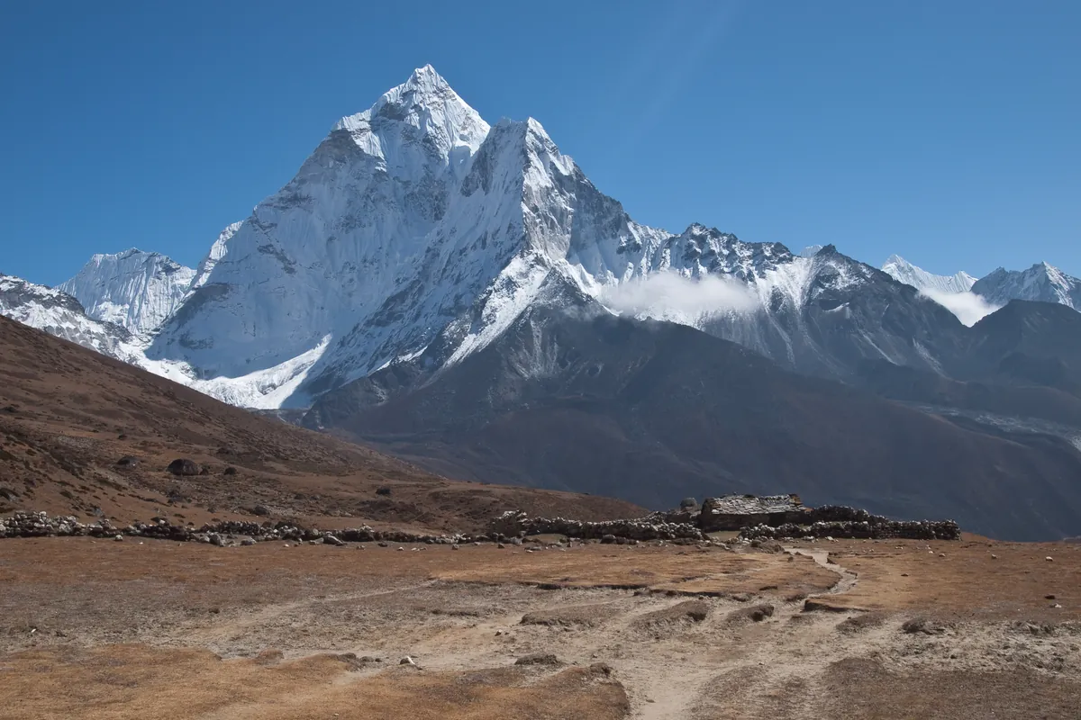
The Southwest Ridge is the iconic classic route on Ama Dablam and one of the finest technical ridge ascents in the Himalayas. First climbed on January 15, 1961, by Sir Edmund Hillary's Silver Hut Expedition team, the route climbs soaring granite towers, knife-edge snow flutings, and steep ice beneath the hanging Dablam glacier. The route features famous technical cruxes including the vertical granite Yellow Tower (UIAA 5.7), the breathtaking exposed Mushroom Ridge, and a steep final ice pitch to the 6,812-meter apex.
Historical Expeditions (1)
1961 Hillary Silver Hut Ama Dablam Expedition
Organized under Sir Edmund Hillary's legendary 1960-61 Silver Hut Scientific Expedition, team members forged the historic first ascent of Ama Dablam (6,812m) via the Southwest Ridge on March 13, 1961.
Summit Chronicles & Stories (1)
1961 Ama Dablam: The Silver Hut Himalayan First Ascent
How Sir Edmund Hillary's Silver Hut team made the historic first ascent of Ama Dablam's Southwest Ridge in March 1961.
Frequently Asked Questions: Ama Dablam
What is the elevation of Ama Dablam and why is it famous?
Ama Dablam stands at 6,812 meters (22,349 ft) in the Khumbu Himal of Nepal. Renowned for its soaring granite ridges and hanging glaciers, it is celebrated as the "Matterhorn of the Himalayas".
How did Sir Edmund Hillary’s expedition achieve the first ascent of Ama Dablam?
As part of Hillary’s 1960–1961 Silver Hut Expedition, assault climbers Mike Gill, Barry Bishop, Michael Ward, and Wally Romanes made the historic first ascent on January 15, 1961, via the technical Southwest Ridge.
What is the Dablam on Ama Dablam and what danger does it present?
The Dablam is a massive hanging glacier situated beneath the summit pyramid at roughly 6,300 meters. Named after a Sherpa traditional jewel box, its ice collapses represent the primary objective avalanche hazard on the mountain.
Documented Sources & Archival Citations
- Himalayan Scientific and Mountaineering Expedition 1960-61(Alpine Journal / Michael Ward)
Supporting claim: Official dispatch and first ascent record of Ama Dablam via Southwest Ridge
Accessed/Documented: 1961 - High in the Thin Cold Air(Edmund Hillary and Desmond Doig / Doubleday)
Supporting claim: Detailed chronicle of the 1960-61 Silver Hut Expedition and Ama Dablam conquest
Accessed/Documented: 1962